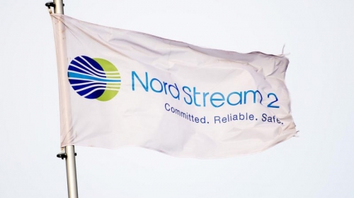
Nord Stream 2, une des clés de la guerre en Ukraine
Daniel Miguel López Rodríguez
Source: https://posmodernia.com/nord-stream-2-una-de-las-claves-de-la-guerra-de-ucrania/
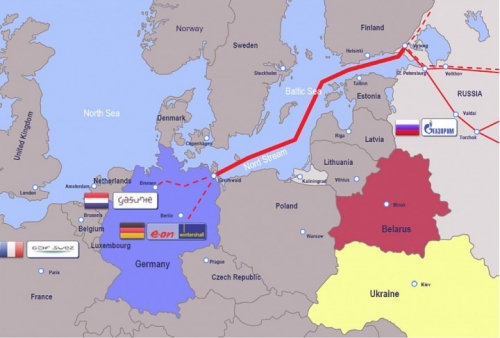
Le flux du Nord
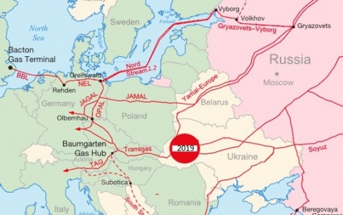
Le sous-sol ukrainien contient un réseau de gazoducs par lequel passe une partie de l'approvisionnement russe vers l'Europe. Entre 2004 et 2005, 80 % du gaz russe destiné à l'Europe a transité par le sous-sol ukrainien. Lorsque Gazprom (le géant russe de l'énergie appartenant à l'État) a interrompu l'approvisionnement des Ukrainiens en janvier 2006 et en janvier 2009, ces derniers ont saisi le gaz destiné à l'Europe, ce qui a entraîné des pertes énormes pour ces pays, qui sont très dépendants du gaz russe, et a jeté un sérieux discrédit sur la Russie en tant que fournisseur.
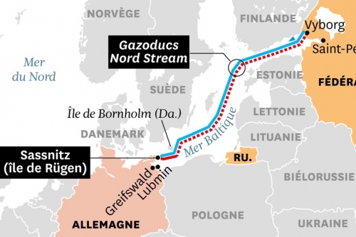
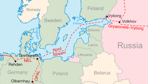
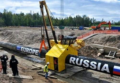
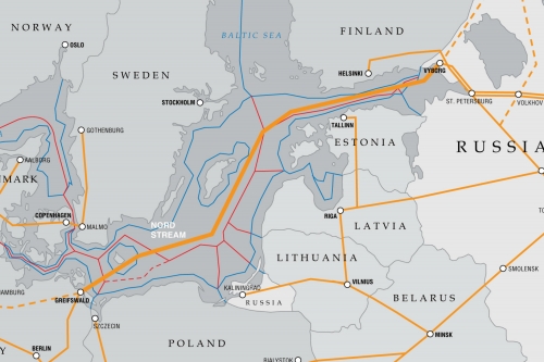
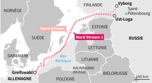
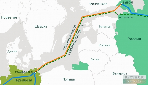
Afin d'éviter ce transit ukrainien, les Russes ont décidé de construire deux nouveaux gazoducs. Gazprom a fait valoir que le fait de relier un gazoduc directement à l'Allemagne sans avoir besoin de passer par des pays de transit permettrait d'éviter que les exportations de gaz russe vers l'Europe occidentale ne soient coupées, comme cela s'est produit deux fois auparavant. C'est ainsi qu'est né le projet Nord Stream (Севеверный поток), un gazoduc qui relierait la Russie à l'Europe (directement à l'Allemagne via la mer Baltique) sans devoir passer par l'Ukraine ou la Biélorussie.
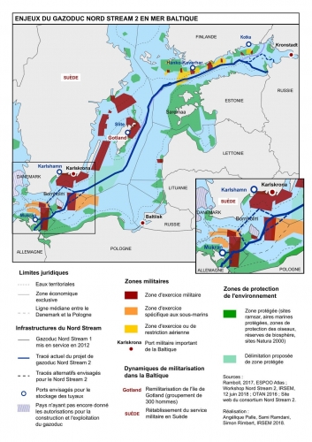
En avril 2006 déjà, le ministre polonais de la défense, Radek Sikorski, comparait les accords sur la construction d'un gazoduc au pacte de non-agression germano-soviétique, le pacte Ribbentrop-Molotov signé aux premières heures du 24 août 1939, car la Pologne est particulièrement sensible aux accords passés par-dessus sa tête (https://www.voanews.com/a/a-13-polish-defense-minister-pi... ). Tout pacte conclu par la Russie et l'Allemagne y fera penser et sera diabolisé (telle est la simplicité de la propagande, mais elle est tout aussi efficace non pas en raison du mérite des propagandistes mais du démérite du vulgaire ignorant, qui abonde).
Le ministre suédois de la défense, Mikael Odenberg, a indiqué que le projet constituait un danger pour la politique de sécurité de la Suède, car le gazoduc traversant la Baltique entraînerait la présence de la marine russe dans la zone économique de la Suède, ce que les Russes utiliseraient au profit de leurs renseignements militaires. En fait, Poutine justifierait la présence de la marine russe pour assurer la sécurité écologique.
L'hebdomadaire allemand Stern a émis l'hypothèse que le câble à fibre optique et les stations relais le long du gazoduc pourraient être utilisés pour l'espionnage russe, mais Nord Stream AG (le constructeur du gazoduc) a répondu en arguant qu'un câble de contrôle à fibre optique n'était pas nécessaire et n'avait même pas été prévu. Le vice-président du conseil d'administration de Gazprom, Alexander Medvedev, minimise la question en soulignant que "certaines objections sont soulevées qui sont risibles : politiques, militaires ou liées à l'espionnage. C'est vraiment surprenant car dans le monde moderne, il est ridicule de dire qu'un gazoduc est une arme dans une guerre d'espionnage" (https://web.archive.org/web/20070927201444/ et http://www.upstreamonline.com/live/article138001.ece ). Où que soient les Russes, on craint toujours les espions (on ne se méfie pas autant des Ricains, malgré les révélations d'Edward Snowden : l'enfer, c'est toujours les autres).
Le Rockefellerien Greenpeace se plaindrait également de la construction du gazoduc, car il traverserait plusieurs zones classées comme aires marines de conservation.
Le 13 juin 2007, face aux préoccupations écologiques, le ministre russe des Affaires étrangères, Sergei Lavrov, a déclaré que "la Russie respecte pleinement le désir d'assurer la durabilité environnementale à 100 % du projet et soutient entièrement cette approche, et toutes les préoccupations environnementales seront traitées dans le cadre du processus d'évaluation de l'impact environnemental" (https://www.upstreamonline.com/online/russia-backs-green-... ).
Le gazoduc devait être inauguré le 8 novembre 2011 lors d'une cérémonie dans la municipalité de Lubmin (Mecklembourg-Poméranie occidentale) par la chancelière Angela Merkel et le président russe Dmitri Medvedev ; étaient également présents le Premier ministre français François Fillon et le Premier ministre néerlandais Mark Rutte.
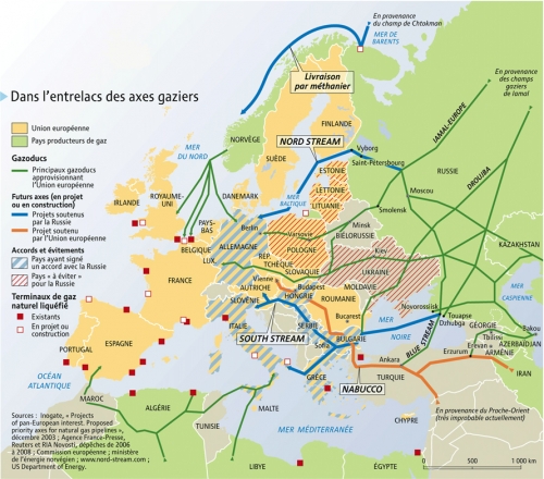
Il était également prévu de construire South Stream, un gazoduc qui devait relier la Russie à la Bulgarie en traversant la mer Noire jusqu'à la Grèce et l'Italie. Mais il a finalement été annulé au profit de Blue Stream, qui transporte du gaz naturel du sud de la Russie vers la Turquie via la mer Noire. Grâce à ce gazoduc, la Turquie est le deuxième plus grand importateur de gaz russe, juste derrière l'Allemagne.
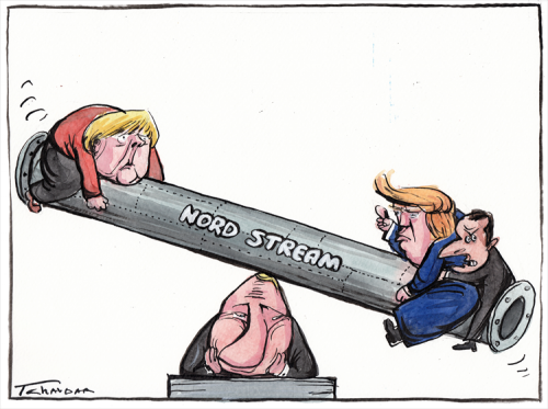
Alors que l'Allemagne a pu réaliser le projet Nord Stream 1, la Grèce et l'Italie ont vu leur projet South Stream mis au rebut. C'est un signe de qui a le plus de pouvoir dans la prétentieuse Union européenne. Mais Nord Stream 2 n'est pas allé aussi loin et - comme nous le verrons - les Allemands se sont pliés aux diktats des Américains.
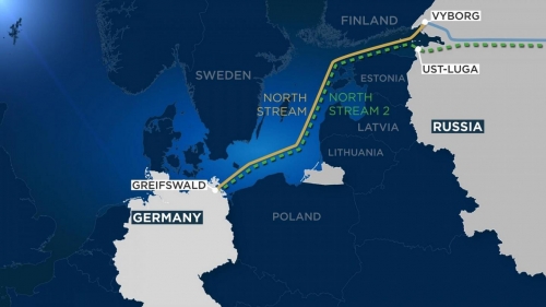
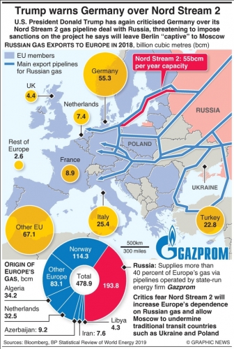
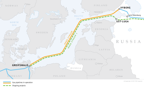
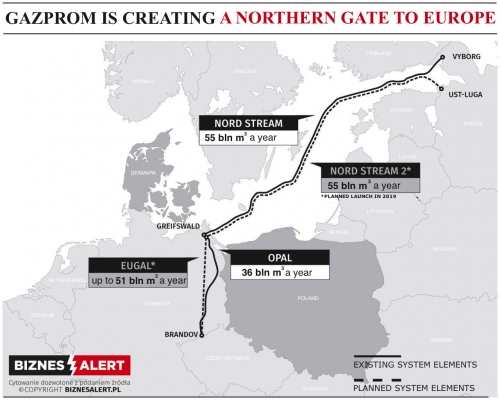
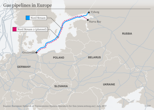
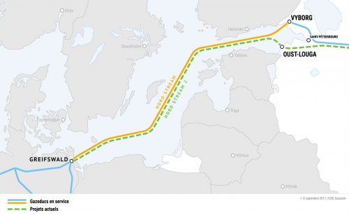
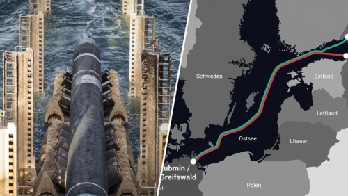
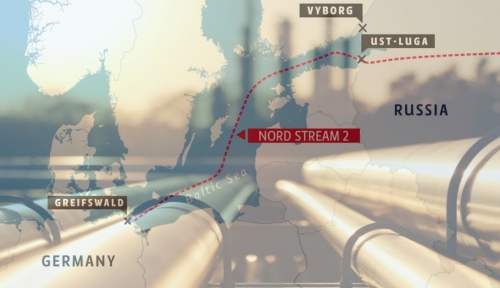
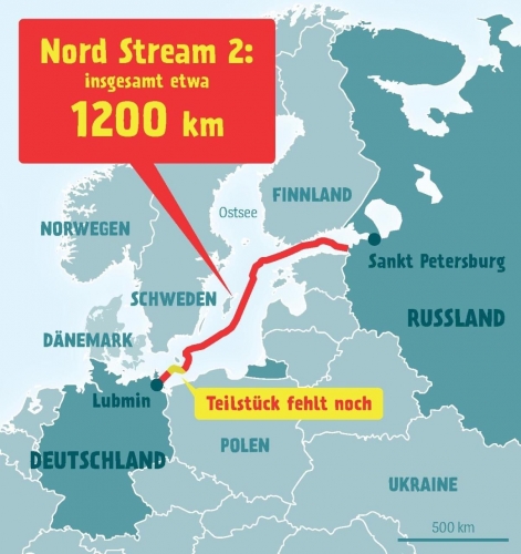
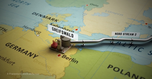
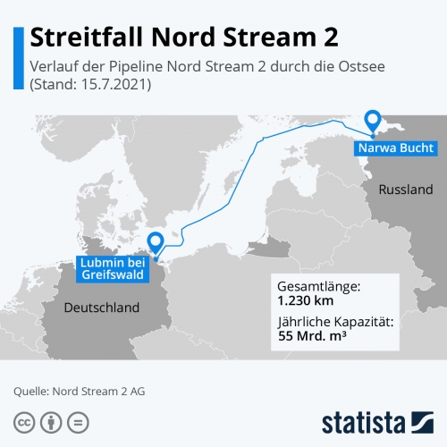
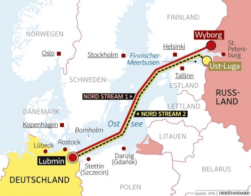
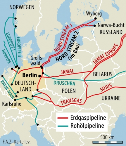
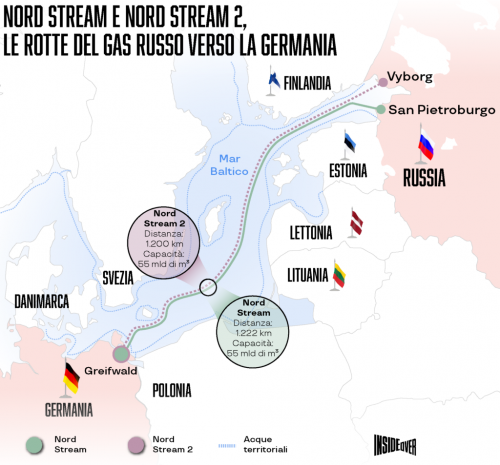
Nord Stream 1 se compose de deux pipelines allant de Vyborg (nord-ouest de la Russie) à Greifswald (nord-est de l'Allemagne). Il a la capacité de transporter 55 milliards de mètres cubes par an, même si en 2021, il était capable de transporter 59,2 milliards de mètres cubes. Il s'agit du gazoduc par lequel transite le plus grand volume de gaz à destination de l'UE.
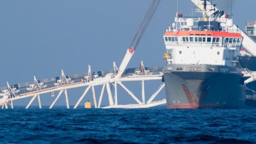
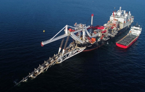
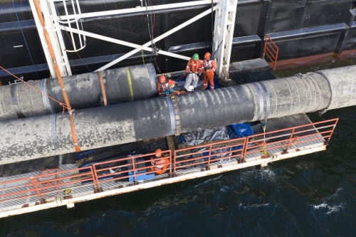
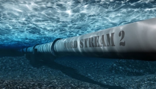
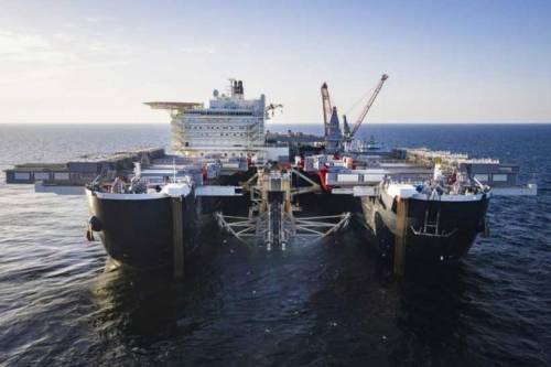
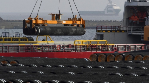
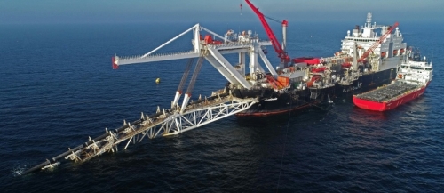
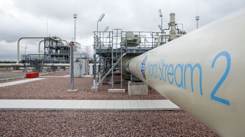
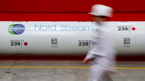
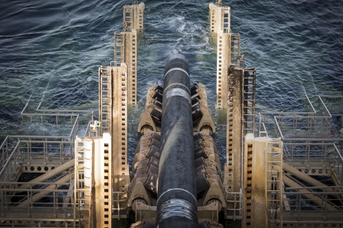
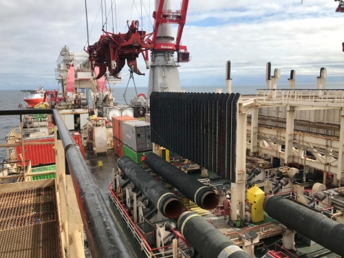
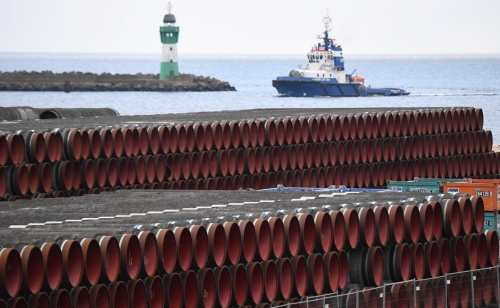
Les travaux sur le gazoduc Nord Stream 2 ont duré de 2018 à 2021, et on estime que le matériau du gazoduc peut durer environ 50 ans. Le pipeline part de la station de compression Slavyanskaya, près du port d'Ust-Luga (dans le district Kingiseppsky de l'Oblast de Leningrad), et va jusqu'à Greifswald (Poméranie occidentale). En 2019, la société suisse Allsea, qui était chargée de poser le gazoduc, a abandonné le projet et Gazprom a dû le mener à bien par ses propres moyens. La première ligne a été achevée en juin 2021 et la seconde en septembre. Son ouverture était prévue pour le milieu de l'année 2022, ce qui devait permettre de doubler le gaz transporté pour atteindre 110 milliards de mètres cubes par an. Outre Gazprom, les partenaires pour la construction de Nord Stream 2 ont été Uniper, Wintershall, OMV, Engie et Shell plc.
Le gouvernement allemand a approuvé le projet en mars 2018, afin d'éloigner l'Allemagne du nucléaire et du charbon (c'est-à-dire pour des raisons environnementales, toujours aussi sensibles en Allemagne, déjà depuis des temps pas particulièrement démocratiques). Les coûts du gazoduc sont estimés à 9,9 milliards d'euros, Gazprom apportant 4,75 milliards d'euros et ses partenaires le reste.
Nord Stream 2 aurait complété les troisième et quatrième lignes (par rapport aux première et deuxième lignes de Nord Stream 1). À travers la Baltique, Nord Stream 1 et 2 suivent fondamentalement le même itinéraire. Les deux pipelines tirent leur gaz des gisements de la péninsule de Yamal et des baies d'Ob et de Taz. Avec ces deux gazoducs (avec quatre lignes au total), l'Allemagne fournirait du gaz russe à d'autres pays, ce qui améliorerait sans aucun doute la situation sur le marché européen et permettrait de surmonter la crise énergétique. Les Allemands sont allés jusqu'à affirmer que le Nord Stream 2 serait plus rentable que les livraisons terrestres via l'Europe de l'Est. La Russie a fourni 35,4 % du gaz arrivant en Allemagne (et avec Nord Stream 2, elle aurait doublé cette quantité) et 34 % du pétrole.
Les principaux opposants à Nord Stream 2 ont été les pays baltes, la République tchèque, la Slovaquie, la Hongrie ( ?), la Roumanie, la Croatie, la Moldavie et principalement la Pologne et l'Ukraine, tous soutenus par la Commission européenne et les États-Unis. Ces pays se sont opposés à Nord Stream 2 au motif qu'un gazoduc direct vers l'Allemagne pourrait entraîner l'arrêt de leur approvisionnement en énergie et les priver des lucratifs frais de transit.
Chronologie de la politique américaine contre Nord Stream 2
Les plaintes américaines contre le gazoduc ne sont pas propres à l'administration Biden (qui a subi la pression de ses collègues démocrates pour adopter une ligne dure contre la Russie, qualifiant ainsi Poutine de "meurtrier" - comme si l'administration Obama dont il était le vice-président n'avait pas commis d'innombrables crimes de guerre, bien plus que la Russie ne l'a jamais fait : mais le premier président afro-américain est un démon qui "ne sent pas le soufre"). Déjà sous Obama, les protestations ont commencé alors que le projet n'avait pas encore totalement pris forme (l'idée du projet a commencé à prendre forme en octobre 2012).
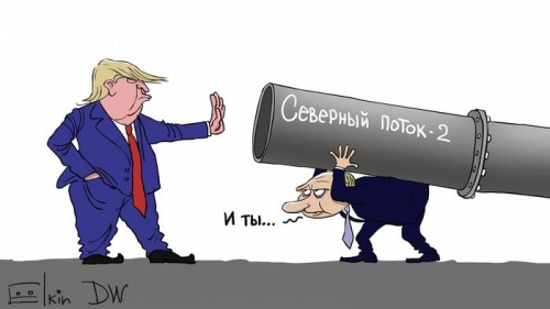
Sous l'administration Trump, les plaintes se sont poursuivies et n'ont jamais cessé, même si Trump a d'abord affirmé qu'il n'appliquerait pas la loi contre les ennemis de l'Amérique par le biais de sanctions sur les exportations énergétiques russes, mais il a rapidement changé d'avis. M. Trump a même menacé d'imposer des droits de douane aux pays de l'UE et a proposé de rouvrir les négociations en vue de conclure un accord commercial entre les États-Unis et l'UE si le projet était annulé.
Le 27 janvier 2018, coïncidant avec le 73e anniversaire de la libération du camp de concentration d'Auschwitz, le secrétaire d'État Rex Tillerson (un ancien PDG d'Exxon Mobil, c'est-à-dire un homme de Rockefeller infiltré dans l'administration Trump, qui sera finalement évincé par le plus loyal Mike Pompeo) a fait valoir que les États-Unis et la Pologne s'opposaient à Nord Stream 2 en raison du danger qu'il représente pour la sécurité et la stabilité énergétiques de l'Europe, "tout en donnant à la Russie un outil supplémentaire pour politiser le secteur de l'énergie" ( https://www.expansion.com/economia/politica/2018/01/27/5a... ).
Les sénateurs américains des deux partis se sont inquiétés en mars 2018, lorsque le gouvernement allemand a approuvé le projet, et ont écrit que "en contournant l'Ukraine, Nord Stream II éliminera l'une des principales raisons pour lesquelles la Russie évite un conflit à grande échelle dans l'est de l'Ukraine, comme le Kremlin le sait bien" (https://www.cfr.org/in-brief/nord-stream-2-germany-captiv... ).
Le transit ukrainien fournissait autrefois 44 % du gaz russe à l'UE, ce qui permettait aux caisses de l'État (de plus en plus corrompu) d'empocher quelque 3 milliards de dollars par mois. Mais avec Nord Stream 2, cela devait changer et le transit par le sous-sol ukrainien devait être encore décuplé. Cela aurait fait perdre à l'Ukraine 3 % de son PIB. L'Ukraine y voyait une atteinte à sa souveraineté, mais aussi à la sécurité énergétique collective de l'Europe dans son ensemble, car le transit du gaz par l'Ukraine dissuade l'agression russe. L'ouverture de Nord Stream 2, qui aurait fait de l'Allemagne la première plaque tournante du gaz en Europe, aurait mis fin à cette situation.
En janvier 2019, l'ambassadeur américain en Allemagne, Richard Grenell, a envoyé une lettre aux entreprises qui construisent le gazoduc, les exhortant à abandonner le projet et les menaçant de sanctions si elles le poursuivent. En décembre de la même année, les sénateurs républicains Ted Cruz et Ron Johnson ont également fait pression sur les entreprises impliquées dans le projet.
Le président du Conseil européen Donald Tusk, le Premier ministre polonais Mateusz Morawiecki et le ministre britannique des Affaires étrangères de l'époque Boris Johnson ont protesté contre la construction de Nord Stream 2. Tusk a clairement indiqué que le gazoduc n'était pas dans l'intérêt de l'Union européenne. Les fonctionnaires de la Commission européenne ont déclaré que "Nord Stream 2 n'améliore pas la sécurité énergétique [de l'UE]" (https://euobserver.com/world/141584 ).
Nord Stream 2 est quelque chose qui a divisé l'UE. Bien que lorsque Donald Trump était dans le bureau ovale de la Maison Blanche, le projet ne semblait pas si mauvais, et la France, l'Autriche et l'Allemagne, plus la Commission européenne, ont critiqué les États-Unis (c'est-à-dire l'administration Trump) pour les nouvelles sanctions contre la Russie au sujet du pipeline, se plaignant que les États-Unis menaçaient l'approvisionnement énergétique de l'Europe.
Le chancelier autrichien Christian Kern et le ministre allemand des Affaires étrangères Sigman Gabriel se sont plaints dans une déclaration commune : "L'approvisionnement énergétique de l'Europe est l'affaire de l'Europe, pas celle des États-Unis d'Amérique" (https://www.usnews.com/news/business/articles/2017-06-15/... ). Et ils ajoutent : "Menacer les entreprises d'Allemagne, d'Autriche et d'autres États européens de sanctions sur le marché américain si elles participent ou financent des projets de gaz naturel comme Nord Stream 2 avec la Russie introduit une qualité complètement nouvelle et très négative dans les relations entre l'Europe et les États-Unis" (https://www.politico.eu/article/germany-and-austria-warn-... ). Mais - comme nous le verrons - les politiciens allemands, avec un gouvernement social-démocrate, n'ont pas été aussi audacieux avec l'administration Biden.
Isabelle Kocher, PDG du groupe ENGIE (un groupe local français qui distribue de l'électricité, du gaz naturel, du pétrole et des énergies renouvelables), a critiqué les sanctions américaines et a affirmé qu'elles tentaient de promouvoir le gaz américain en Europe (ce qui est la clé de toute l'affaire). Olaf Scholz, lorsqu'il était ministre des finances dans le gouvernement de coalition dirigé par Merkel, a rejeté les sanctions comme "une intervention sévère dans les affaires intérieures allemandes et européennes". Un porte-parole de l'UE a critiqué "l'imposition de sanctions contre des entreprises de l'UE faisant des affaires légitimes" (https://www.dw.com/en/germany-eu-decry-us-nord-stream-san... ).
Le ministre allemand des Affaires étrangères, Heiko Mass, a déclaré sur Twitter que "la politique énergétique européenne se décide en Europe, pas aux États-Unis". M. Lavrov a affirmé que le Congrès américain "est littéralement submergé par le désir de tout faire pour détruire" les relations avec la Russie (https://www.cnbc.com/2019/12/16/ukraine-and-russia-look-t... ). Toutefois, il convient de noter que l'Allemagne a fortement soutenu les sanctions contre la Russie suite à l'annexion de la Crimée en 2014.
L'Association allemande des entreprises orientales a déclaré dans un communiqué que "les États-Unis veulent vendre leur gaz liquéfié en Europe, pour lequel l'Allemagne construit des terminaux. Si nous arrivons à la conclusion que les sanctions américaines visent à chasser les concurrents du marché européen, notre enthousiasme pour les projets bilatéraux avec les États-Unis se refroidira considérablement" (https://www.dw.com/en/nord-stream-2-gas-pipeline-faces-sa... ).
Le 21 décembre 2019, Trump a signé une loi imposant des sanctions aux entreprises ayant contribué à la construction de l'oléoduc, qui a été interrompue après la signature de Trump, mais reprendrait en décembre 2020, après l'élection de Joe Biden à la présidence. Mais immédiatement, le 1er janvier 2021, un projet de loi annuel sur la politique de défense adopté par le Congrès américain prévoyait des sanctions pour les entreprises travaillant sur le pipeline ou le sécurisant. Le 26 janvier, la Maison Blanche a annoncé que le nouveau président estime également que "Nord Stream 2 est une mauvaise affaire pour l'Europe", et que son administration va donc "revoir" les nouvelles sanctions (https://www.reuters.com/article/us-usa-biden-nord-stream-... ).
Ainsi, le bipartisme au Capitole s'est prononcé contre l'achèvement du gazoduc Nord Stream 2, non pas parce que c'est "une mauvaise affaire pour l'Europe", mais parce que c'est une mauvaise affaire pour les États-Unis. Sur ce point, les "mondialistes" et les "patriotes" sont d'accord.
Le 30 juillet 2020, le secrétaire d'État Mike Pompeo s'est adressé au Sénat en critiquant la construction de Nord Stream 2 : "Nous ferons tout ce qui est en notre pouvoir pour nous assurer que ce gazoduc ne menace pas l'Europe. Nous voulons que l'Europe dispose de ressources énergétiques réelles, sûres, stables, sûres et non convertibles". C'est comme s'il disait : "Nous ferons tout ce que nous pouvons pour nous assurer que ce pipeline ne menace pas les États-Unis. Nous voulons que l'Europe dispose de ressources énergétiques qu'elle achète aux États-Unis". Il a ajouté que le département d'État et le département du Trésor "ont très clairement indiqué, dans nos conversations avec ceux qui ont des équipes sur place, la menace expresse que représente pour eux la poursuite des travaux d'achèvement du pipeline" (https://www.rferl.org/a/pompeo-u-s-will-do-everything-to-... ).
Le 20 avril 2021, on pouvait lire sur le site Web du Conseil européen des relations étrangères (think tank de Soros) : "Ce serait mauvais pour l'Europe si la pression américaine devait forcer l'annulation du gazoduc et laisser l'Allemagne et les autres États membres dont les entreprises participent à sa construction amers et meurtris. Ce serait également mauvais pour l'Europe si le gazoduc finissait par balayer les réticences de la Pologne et par dépeindre l'Allemagne comme un acteur égoïste qui ne se soucie pas de ses partenaires. L'un ou l'autre résultat affaiblirait également l'alliance transatlantique et, plus ou moins directement, profiterait à Moscou... si Washington arrête le projet, Moscou trouvera une autre raison de rejeter l'Europe comme un acteur politique qui manque de crédibilité. Bien sûr, cela ne doit pas signifier que l'Europe doit sauver Nord Stream 2 juste pour impressionner la Russie. Le raisonnement de l'UE devrait avoir des racines plus profondes que cela". Il s'agit donc d'un "problème de gestion des relations" (https://ecfr.eu/article/the-nord-stream-2-dispute-and-the... ).
Cependant, le 19 mai 2021, le gouvernement américain a levé les sanctions contre Nord Stream AG, mais a imposé des sanctions contre quatre banques russes et cinq sociétés russes. Sergueï Ryabkov, vice-ministre russe des Affaires étrangères, a salué cette démarche et y a vu "une opportunité pour une transition progressive vers la normalisation de nos liens bilatéraux" (https://www.bbc.com/news/world-us-canada-57180674 ).
Le sénateur républicain Jim Risch a déclaré qu'une telle démarche était "un cadeau à Poutine et ne fera qu'affaiblir les États-Unis" (https://www.reuters.com/business/energy/us-waive-sanction...).
Yurity Vitrenko de Naftogaz (la compagnie pétrolière et gazière d'État ukrainienne) s'opposerait à cette démarche et affirmerait que l'Ukraine fait pression sur les États-Unis pour qu'ils réimposent des sanctions afin d'empêcher l'ouverture du pipeline. Biden prétendrait qu'il a mis fin aux sanctions parce que le pipeline était presque terminé et parce que les sanctions avaient nui aux relations entre les États-Unis et l'Union européenne.
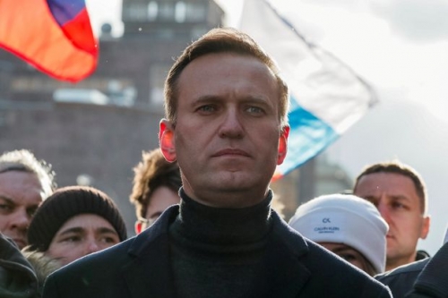
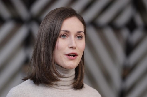
Le président ukrainien, alors inconnu en Occident, Volodymyr Zelensky, s'est dit "surpris et déçu" par la décision de l'administration Biden, qui a également refusé de sanctionner le PDG de Nord Stream AG, Mathias Warning, un allié de Poutine.
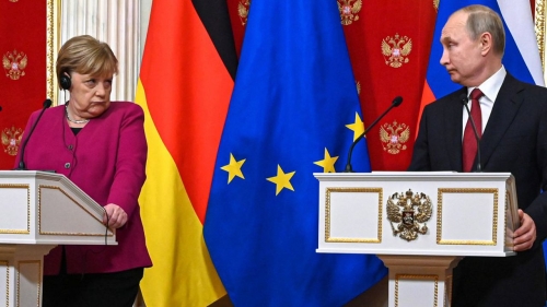
Cependant, en juin 2021, la pose des deux lignes de pipelines a été entièrement achevée. Le 20 juillet 2021, Biden et une Angela Merkel sortante ont convenu que les États-Unis pourraient sanctionner la Russie si elle utilisait Nord Stream 2 comme une "arme politique", dans le but d'empêcher la Pologne et l'Ukraine de manquer de gaz russe.
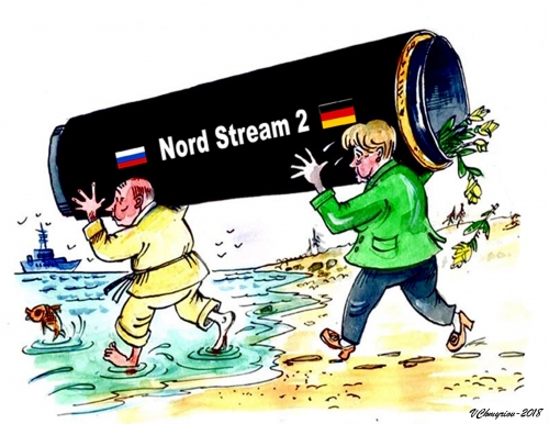
Mme Merkel est une atlantiste avouée et n'était pas exactement enthousiaste à l'égard du projet Nord Stream 2, mais elle ne voyait aucun moyen de faire marche arrière. Pour elle, c'était une situation très délicate.
L'Ukraine obtiendrait un prêt de 50 millions de dollars pour investir dans les technologies vertes jusqu'en 2024, et l'Allemagne créerait un fonds d'un milliard de dollars pour la transition de l'Ukraine vers l'énergie verte, afin de compenser la perte de droits de douane due au fait que tout le gaz russe qui devait passer par le gazoduc Nord Stream 2 ne passerait pas par son sous-sol.
Après cette étrange hésitation, le département d'État américain prendra une décision complète et imposera, en novembre 2021, de nouvelles sanctions financières aux entreprises russes liées à Nord Stream 2.
Le 9 décembre 2021, le Premier ministre polonais Mateusz Marawiecki a fait pression sur le nouveau chancelier allemand, le social-démocrate Olaf Scholz, pour qu'il n'inaugure pas le Nord Stream 2 et ne cède pas à la pression russe, et donc "ne permette pas que le Nord Stream 2 soit utilisé comme un instrument de chantage contre l'Ukraine, comme un instrument de chantage contre la Pologne, comme un instrument de chantage contre l'Union européenne" (https://www.metro.us/polish-pm-tells-germanys/ ).
Après avoir détecté des troupes russes à la frontière orientale de l'Ukraine, le secrétaire d'État Antony Blinken a annoncé de nouvelles sanctions le 23 décembre.
Olaf Scholz serait pressé d'arrêter l'ouverture du pipeline lors du sommet de l'UE. Le 7 février 2022, il rencontrera Biden à la Maison Blanche et, lors de la conférence de presse, il déclarera que les États-Unis et l'Allemagne sont "absolument unis et nous ne prendrons pas de mesures différentes". Nous prendrons les mêmes mesures et elles seront très, très dures pour la Russie et ils doivent le comprendre. Toutes les mesures que nous prendrons, nous les prendrons ensemble. Comme l'a dit le président [Biden], nous nous y préparons. Vous pouvez comprendre et vous pouvez être absolument sûrs que l'Allemagne sera de concert avec tous ses alliés et surtout les États-Unis, que nous prendrons les mêmes mesures. Il n'y aura aucune différence dans cette situation. Je dis à nos amis américains que nous serons unis. Nous agirons ensemble et nous prendrons toutes les mesures nécessaires et toutes les mesures nécessaires que nous prendrons ensemble" (https://edition.cnn.com/2022/02/07/politics/biden-scholz-... ).
On peut voir qu'il ne se plaignait plus de l'intervention des États-Unis "dans les affaires intérieures allemandes et européennes", comme on l'a vu dire lorsqu'il était ministre des finances dans le gouvernement de coalition avec Merkel, alors que Trump était à la Maison Blanche.
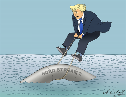
Pour sa part, Joe Biden a averti que si la Russie envahit l'Ukraine, avec "des chars et des troupes", comme cela finirait par arriver, "alors il n'y aura plus de Nord Stream 2 : nous y mettrons fin" (https://edition.cnn.com/2022/02/07/politics/biden-scholz-... ).
Face aux menaces de Biden envers la Russie, Scholz a gardé un silence timide, ne disant absolument rien sur l'ingérence flagrante des États-Unis dans les relations économiques de l'Allemagne avec la Russie. Il s'est plié aux diktats de Washington.
Le 15 février, Scholz devait rencontrer Poutine à Moscou, où le dirigeant russe a affirmé que le gazoduc renforcerait la sécurité énergétique européenne et qu'il s'agissait d'une question "purement commerciale" (https://www.reuters.com/business/energy/putin-says-nord-s... ). Comme si l'économie n'était pas une économie-politique et une question géopolitique de la plus haute importance et, comme nous l'avons vu, d'une transcendance vitale.
Scholz a affirmé que les négociations avaient été intenses mais confiantes et a supplié la Russie d'éviter toute interprétation dans le conflit avec l'Ukraine.
Lors de la conférence de presse, Poutine est allé jusqu'à dire : "L'Allemagne est l'un des principaux partenaires de la Russie. Nous nous sommes toujours efforcés de favoriser l'interaction entre nos États. L'Allemagne est le deuxième partenaire commercial extérieur de la Russie, après la Chine. Malgré la situation difficile causée par la pandémie de coronavirus et la volatilité des marchés mondiaux, à la fin de 2021, les échanges mutuels ont augmenté de 36 % et ont atteint près de 57 milliards. Dans les années 1970, nos pays ont mis en œuvre avec succès un projet historique. Il s'appelait "Gaz pour les tuyaux". Et depuis lors, les consommateurs allemands et européens sont approvisionnés en gaz russe de manière fiable et sans interruption. Aujourd'hui, la Russie satisfait plus d'un tiers des besoins de l'Allemagne en matière de transport d'énergie" (https://1prime.ru/exclusive/20220220/836108179.html ).
Le projet "Gaz pour les pipelines" a été possible malgré la guerre froide. Les États-Unis ont tenté d'empêcher la construction du gazoduc Urengoy-Pomary-Uzhgorod et ont également essayé d'empêcher les entrepreneurs allemands de participer au projet, bien qu'il ait finalement été construit en 1982-1984 et officiellement ouvert en France, complétant le système de transport transcontinental de gaz Sibérie occidentale-Europe occidentale qui était en place depuis 1973. Ce gazoduc traverse l'Ukraine, pompant du gaz vers la Slovaquie, la Hongrie et la Roumanie. À cette époque, l'URSS n'avait pas la capacité de produire les pipelines nécessaires. Après la construction, d'importantes livraisons de gaz en provenance de Russie ont commencé, depuis le gigantesque champ de Vengoyskoye vers l'Allemagne et d'autres pays européens. Les conséquences d'une telle quantité de gaz ont été le remplacement du charbon américain sur le marché européen, et la RFA a bénéficié d'un énorme élan économique. Nous constatons que les accords gaziers entre la Russie et l'Europe (alors l'URSS) n'ont pas profité aux États-Unis, où ils en prendraient acte.
Scholz a ensuite rencontré Zelensky, accusé d'avoir utilisé le "livre de jeu de Merkel" en évitant les questions sur le gazoduc lors de la conférence de presse qu'il a donnée avec le président ukrainien (https://www.telegraph.co.uk/news/2022/02/14/olaf-scholz-f... ).
La présidente de la Commission européenne, Ursula von der Leyen, a affirmé que l'avenir du pipeline dépendrait du comportement de la Russie en Ukraine. Le 19 février, elle a déclaré à la Conférence sur la sécurité de Munich que l'Europe ne pouvait pas être aussi dépendante de la Russie pour ses besoins énergétiques (peut-être veut-elle qu'elle soit dépendante des États-Unis, et pas seulement sur le plan énergétique mais aussi sur le plan géopolitique, ce qui est la conséquence logique). "Une Union européenne forte ne peut pas être aussi dépendante d'un fournisseur d'énergie qui menace de déclencher une guerre sur notre continent. Nous pouvons imposer des coûts élevés et des conséquences graves sur les intérêts économiques de Moscou. La pensée bizarre du Kremlin, qui découle directement d'un passé sombre, pourrait coûter à la Russie un avenir prospère. Nous espérons encore que la diplomatie n'a pas dit son dernier mot" (https://www.dw.com/en/natos-jens-stoltenberg-urges-russia... ).
Le 22 février, le lendemain de la reconnaissance par la Russie des républiques populaires de Donetsk et de Lougansk, Olaf Scholz, qui a toujours été favorable au projet mais qui venait de voir Biden (alors qu'il devait rendre visite à Poutine immédiatement après), a suspendu la certification de Nord Stream 2. <...> Il s'agit d'une étape nécessaire pour que la certification du pipeline ne puisse avoir lieu maintenant. Sans cette certification, Nord Stream 2 ne peut être lancé" (https://www.vedomosti.ru/economics/articles/2022/02/22/91... ). La ministre allemande des Affaires étrangères, Annalena Berbock, a déclaré aux journalistes que le gouvernement allemand avait "gelé" le projet.
Le 23 février, M. Biden a ordonné des sanctions contre l'exploitant du gazoduc, Nord Stream 2 AG, ainsi que contre des responsables de la société. "Ces mesures sont une autre partie de notre tranche initiale de sanctions en réponse aux actions de la Russie en Ukraine. Comme je l'ai dit clairement, nous n'hésiterons pas à prendre de nouvelles mesures si la Russie poursuit l'escalade." Ces sanctions ont été imposées après des "consultations étroites" entre les gouvernements américain et allemand. Et il a remercié Scholz pour son "étroite coopération et son engagement inébranlable à tenir la Russie responsable de ses actions" ; en d'autres termes, il l'a remercié pour sa soumission aux États-Unis. En reconnaissant les républiques populaires de Donetsk et de Lougansk, Poutine, a déclaré Biden, "a donné au monde une incitation irrésistible à abandonner le gaz russe et à passer à d'autres formes d'énergie" (https://www.rbc.ru/politics/23/02/2022/621684c49a794730b4... ).
Le jour suivant, la Russie commencera une "opération militaire spéciale" en Ukraine. Les États-Unis avaient donc déjà la guerre qu'il leur fallait pour empêcher l'ouverture du gazoduc Nord Stream 2 et la rupture des relations germano-russes ; même si Nord Stream 1 continuerait à transporter du gaz vers l'Allemagne, fonctionnant comme les autres gazoducs approvisionnant l'Europe, dont la Russie empoche quelque 800 millions d'euros par jour, plus 260 millions d'euros pour l'exportation de pétrole.
Le 8 mars, les États-Unis ont interdit toute importation de pétrole et de gaz en provenance de Russie, établissant un record historique pour le prix de l'essence (7 % du pétrole consommé aux États-Unis est russe).
Le 9 mars, le secrétaire de presse du président russe, Dmitry Preskov, a répondu à la sous-secrétaire d'État américaine aux affaires politiques, Victoria Nuland - la femme qui a dit "fuck the EU" (https://www.youtube.com/watch?v=dO80WVMy5E4&ab_channe... ), en déclarant que Nord Stream 2 est "mort et ne sera pas ressuscité" (un jour plus tôt, devant le Congrès américain, elle avait déclaré que le gazoduc n'est qu'"un tas de métal au fond de la mer") - en lui disant que le gazoduc est prêt à être utilisé, en ajoutant que les États-Unis déclarent la guerre économique à la Russie.
Un différend géo-économique et donc géopolitique
Plutôt qu'un projet d'infrastructure dans le pouvoir fédérateur (ou le commerce international) des couches corticales des États concernés, Nord Stream 2 ressemble davantage à un symbole de discorde dans le pouvoir diplomatique, voire militaire, que l'on observe en Ukraine. Il ne fait aucun doute que Nord Stream 2 et tous les gazoducs et oléoducs entraînent des problèmes géopolitiques, car les ressources de base sont intégrées dans les problèmes corticaux de la dialectique des États (l'économie est toujours l'économie-politique ; c'est-à-dire que les deux ne peuvent être compris comme des sphères mégaréales mais comme des concepts conjugués : conceptuellement dissociables, existentiellement inséparables).
Sans aucun doute, comme on l'accuse à juste titre, la Russie utilise sa puissance énergétique comme une arme géopolitique et géostratégique, tout comme les États-Unis. En effet, cette puissance russe est énorme. En additionnant les exportations de pétrole, de gaz et de charbon, la Russie serait le premier exportateur mondial de ces produits.
Si Nord Stream 2 avait été mis en œuvre, les États-Unis auraient perdu leur influence sur l'UE et aussi sur l'Ukraine. Cela rendrait les pays européens, notamment l'Allemagne, encore plus dépendants des ressources énergétiques russes. Certains de ces pays et bien sûr le meneur de la bande, les États-Unis, ont pris position contre la construction de ce pipeline. L'Ukraine est considérée comme l'une des économies les plus touchées si le Nord Stream 2 est mis en service, car une grande quantité de matières premières en provenance de Russie ne passerait plus par son sous-sol (bien que cela affecte également le Belarus, allié plutôt vassal de la Russie).
Les Russes affirment qu'avec Nord Stream 2, le prix du gaz baisserait, car quelque 55 milliards de mètres cubes de gaz seraient transportés par an (plus ou moins la même quantité que Nord Stream 1). Il ne faut pas oublier qu'un peu plus d'un tiers du gaz qui atteint l'Europe provient de Russie.
En Espagne, seulement 10 % du gaz que nous recevons est russe. L'Algérie (alliée historique de la Russie) est notre principal exportateur de gaz (30 % de son gaz finit en Espagne), et le gouvernement de Pedro Sánchez ne fait pas vraiment preuve de tact diplomatique avec ce pays ; il le traite même avec une extrême insouciance, cédant le Sahara au Maroc (abandonnant pour la deuxième fois les pauvres Sahraouis). C'est peut-être la récompense que le sultanat a reçue pour avoir reconnu Israël. Mais puisqu'en Espagne, depuis plusieurs décennies, la politique étrangère est une trahison continue plutôt qu'une politique étrangère ?
Regardez ce que dit le rapport 2019 de l'important groupe de réflexion américain RAND Corporation : "Augmenter la capacité de l'Europe à importer du gaz de fournisseurs autres que la Russie pourrait étirer la Russie sur le plan économique et protéger l'Europe de la coercition énergétique russe. L'Europe avance lentement dans cette direction en construisant des usines de regazéification de gaz naturel liquéfié (GNL). Mais pour être vraiment efficace, cette option nécessiterait que les marchés mondiaux du GNL deviennent plus flexibles qu'ils ne le sont déjà et que le GNL devienne plus compétitif en termes de prix par rapport au gaz russe" (https://www.rand.org/pubs/research_briefs/RB10014.html ).
L'Allemagne verrait sa sécurité énergétique menacée si Nord Stream 2 n'est pas mis en service. Et il ne faut pas oublier que ce projet a été construit à l'initiative de Berlin et non de Moscou. Et pourtant, l'Allemagne s'est rangée du côté de l'Ukraine (se pliant ainsi aux diktats de l'empire de Washington).
Mais il faut garder à l'esprit qu'avec Nord Stream 2, la relation entre la Russie et l'Allemagne ne serait pas exclusivement une relation de dépendance de la seconde vis-à-vis de la première, puisque la Russie dépendrait également de l'Allemagne, c'est-à-dire qu'une relation de coopération serait établie, ce que les États-Unis ne veulent pas. Et l'Allemagne distribuerait à son tour le gaz qui arrive de Russie aux autres pays.
Le problème serait que si ce gazoduc commence à pomper du gaz, les États-Unis pourraient alors perdre la vassalité de l'Allemagne et d'autres pays européens. Les États-Unis ont toujours essayé d'empêcher les relations commerciales entre l'Allemagne et la Russie de s'épanouir (comme ils l'ont fait lorsqu'il s'agissait de la RFA et de l'URSS, comme nous l'avons vu).
D'où les plaintes de Biden (ainsi que celles de Trump, et déjà celles d'Obama), car les États-Unis veulent à tout prix empêcher l'ouverture de Nord Stream 2. Ce gazoduc n'aiderait-il pas la Russie à consolider le leadership allemand dans l'UE ? Bien qu'historiquement, malgré Napoléon, la Russie a eu de meilleures relations avec la France. Et les Russes n'oublient certainement pas les deux guerres mondiales, en particulier la Grande Guerre patriotique.
L'Allemagne a fait valoir que Nord Stream 1 n'empêchait pas le Reich d'adopter une ligne dure contre l'expansionnisme russe. Et, élément crucial, que les États-Unis se sont opposés au projet parce qu'ils voulaient vendre davantage de gaz naturel liquéfié sur les marchés européens (cela résume l'intrigue).
Près d'un quart de la consommation énergétique de l'UE est constituée de gaz naturel, dont un tiers provient de Russie, les pays de l'Est étant évidemment plus dépendants de ce gaz. L'UE obtient 40 % de son gaz de la Russie, ainsi que 27 % de son pétrole. Les États-Unis ne reçoivent pas de gaz russe, bien que - comme nous l'avons déjà dit - ils reçoivent 7 % de leur pétrole (qu'ils ont maintenant l'intention de remplacer par du pétrole vénézuélien). Le 25 mars 2022, l'UE a signé un accord dans lequel les États-Unis fourniront 15 milliards de mètres cubes de gaz liquéfié au marché européen cette année. Et entre maintenant et 2030. Mission accomplie : l'Europe courbe la tête devant son serviteur.
Et comment les États-Unis peuvent-ils se permettre de freiner un projet entre deux nations souveraines derrière un chantier pharaonique à des milliers de kilomètres de distance ? Se pourrait-il que l'Allemagne, qui avec la France dirige l'UE, ne soit rien d'autre qu'un vassal des États-Unis, même si elle a maintenant l'intention de se réarmer ? Et si l'axe franco-allemand est un vassal des États-Unis, l'Espagne, l'Espagne délaissée, ne sera-t-elle pas un vassal des vassaux ? Quoi qu'il en soit, les États-Unis se sont comportés envers l'Allemagne comme le gangster extorqueur : celui qui oblige les commerçants sous la menace d'une arme à acheter ses marchandises. Puis, armés d'un visage en diborure de titane, ils appellent cela un "marché libre".
Selon un rapport de la Commission européenne intitulé "EU-US LNG trade", en 2021, le record d'approvisionnement en gaz naturel liquéfié (GNL) des États-Unis vers l'UE a été battu, dépassant les 22 milliards de mètres cubes. En janvier 2022, elle a déjà atteint 4,4 milliards de mètres cubes (si elle continue à ce rythme, elle atteindra plus de 50 milliards). Mais cela ne suffit pas pour les États-Unis. Bien que la Commission européenne soit favorable à ce que les Yankees soient les principaux fournisseurs de gaz naturel sur le marché européen.
Au vu de tout cela, on pourrait dire que les États-Unis ont fomenté une guerre en Ukraine afin de restreindre la coopération économique de l'UE avec la Russie, ce qui va à l'encontre des intérêts de l'Union, qui s'est comportée dans cette crise comme un ensemble d'États vassaux de Washington ; ce qui est le cas depuis longtemps, pratiquement depuis la Seconde Guerre mondiale, sauf que cela apparaît maintenant de manière embarrassante.
Dans une interview avec Jacques Baud, colonel de l'armée suisse, expert en renseignement militaire et député à l'OTAN et à l'ONU, il a déclaré : "Je suis sûr que Poutine ne voulait pas attaquer l'Ukraine, il l'a dit à plusieurs reprises. De toute évidence, les États-Unis ont exercé des pressions pour déclencher la guerre. Les États-Unis ont peu d'intérêt pour l'Ukraine elle-même. Ce qu'ils voulaient, c'était augmenter la pression sur l'Allemagne pour qu'elle ferme Nord Stream II. Ils voulaient que l'Ukraine provoque la Russie, et si la Russie réagissait, Nord Stream II serait gelé" (https://www.lahaine.org/mundo.php/militar-suizo-experto-d... ).
Le Royaume-Uni semble également devoir bénéficier de son statut de pays de "transit" pour l'approvisionnement en gaz naturel de l'Europe, via le gazoduc traversant la Belgique et les Pays-Bas, qui tentera de se sevrer de sa dépendance au gaz russe, comme le prévoit pour cet été le seul opérateur énergétique britannique qui collecte le gaz de la mer du Nord en Norvège : National Grid. Selon le Daily Telegraph, National Grid pense pouvoir exporter environ 5,1 milliards de m3 vers l'Europe cet été. Elle envisage également d'importer du gaz liquéfié des États-Unis au Royaume-Uni pour le transformer en gaz normal et l'exporter en Europe.
En raison de l'opération militaire russe dans la marine des pays de l'OTAN (pas tous) en Ukraine, la non-ouverture de Nord Stream 2 n'a pas divisé les pays européens, comme ce fut le cas en 2003 avec la guerre en Irak, même si le Royaume-Uni a quitté l'UE. Il semble y avoir un consensus anti-russe (la Hongrie anti-sorosienne est peut-être l'exception, quoique de manière ambiguë).
Pour gagner l'alliance de la Russie contre la Chine, ni l'administration Trump (ce qui était son intention) ni l'administration Biden (qui a montré au monde sa russophobie exacerbée, dans la lignée du trilatéraliste-rockefellerien polonais et américain Zbigniew Brzezinski) n'ont su agir avec tact diplomatique. Et ils devraient savoir que les alliances sont aussi importantes que les forces elles-mêmes. C'est pourquoi la Russie a conquis l'allié chinois, mais toujours avec la crainte que ce dernier ne l'absorbe ou ne la trahisse à un moment donné (l'hypocrisie est notre pain quotidien dans les relations internationales).
L'humiliation du président allemand par Zelensky
Pendant des années, le président allemand Frank-Walter Steinmeier a entretenu une relation cordiale avec Vladimir Poutine, dont il a fait l'éloge en tant que chancelier sous Gerhard Schröder, puis en tant que ministre des affaires étrangères sous Angela Merkel. Et il a également montré son plus grand soutien au projet Nord Stream 2 pendant ces années, jusqu'à juste avant la guerre, ce que, après l'entrée des troupes russes en Ukraine, le chef d'État allemand a admis comme une "erreur manifeste". Une erreur qu'il a entretenue pendant des années, presque une décennie ? Après la diffusion sur Twitter de photos de M. Steinmeier embrassant le ministre russe des Affaires étrangères, Sergueï Lavrov, le président a exprimé ses remords. Pour cela, il ne serait pas le bienvenu à Kiev, et a dû annuler sa visite : "Il semble que ma présence ne soit pas souhaitée" (https://www.elmundo.es/internacional/2022/04/12/6255a91f2... ). "Nous n'avons pas réussi à créer une maison européenne commune qui inclut la Russie. Nous n'avons pas réussi à inclure la Russie dans l'architecture de sécurité globale. Nous nous sommes accrochés à des ponts auxquels la Russie ne croyait plus, comme nos partenaires nous en avaient avertis" (https://ria.ru/20220404/evropa-1781787894.html ). Tout cela montre la honteuse servilité de l'Allemagne envers les États-Unis.
L'ambassadeur ukrainien à Berlin, Andriy Melnyk, poursuit en soulignant que l'Allemagne a "trop d'intérêts particuliers" en Russie et que Steinmeier est en grande partie à blâmer, car il a passé des décennies à tisser une toile d'araignée de contacts avec la Russie (tout comme Merkel, avec qui Poutine a parlé en russe et en allemand). "Beaucoup de ceux qui sont maintenant en charge dans la coalition (allemande) sont impliqués dans cette affaire" (https://www.elmundo.es/internacional/2022/04/12/6255a91f2... ).
Le porte-parole adjoint du gouvernement allemand, Wolfgang Büchner, a calmé les esprits en comprenant "la situation exceptionnelle" que traverse l'Ukraine. Il a déclaré que "l'Allemagne a été et est l'un des plus ardents défenseurs de l'Ukraine... et continuera de l'être. Le président a une position claire et sans équivoque en faveur de l'Ukraine" (https://www.elespanol.com/mundo/europa/20220413/zelenski-... ).
Dans le magazine allemand Spiegel, Steinmeier a rappelé qu'en 2001, Poutine avait prononcé un discours en allemand au Bundestag même : "Le Poutine de 2001 n'a rien à voir avec le Poutine de 2022, que nous voyons maintenant comme un fauteur de guerre brutal et retranché" (https://www.elespanol.com/mundo/europa/20220413/zelenski-... ). Et qu'il attendait toujours "un reste de rationalité de la part de Vladimir Poutine" (https://www.spiegel.de/politik/frank-walter-steinmeier-ue... ).
Mais nous avons déjà montré de manière assez puissante dans les pages du Postmodernisme, en réfléchissant contre l'hystérie des politiciens et des journalistes, que Poutine n'est pas fou : https://posmodernia.com/putin-esta-loco/ .


 del.icio.us
 Digg
Digg Facebook
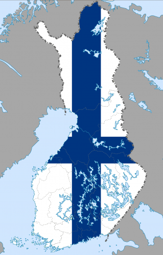
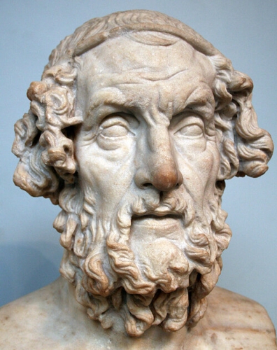

 Notre enquête porte maintenant sur la situation de Troie : il existe aujourd'hui des chercheurs, comme le célèbre professeur anglais Moses Finley, qui nient que la Troie homérique puisse coïncider avec la ville découverte par Heinrich Schliemann sur la colline de Hissarlik en Anatolie. En effet, la ville chantée par Homère était située au nord-est de la mer, en face du "vaste Hellespontine" (dont on sait qu'il est très différent du détroit des Dardanelles), et l'historien médiéval danois Saxo Grammaticus a plusieurs fois fait mention d'un village des "Hellespontines", ennemis des Danois, dans la Baltique orientale. Or, dans une région du sud de la Finlande, entre les villes d'Helsinki et de Turku, on trouve de nombreux noms de lieux similaires aux noms de lieux et de villages alliés aux Troyens mentionnés dans l'Iliade: Askainen, Reso, Karjaa, Nâsti, Lyökki, Tenala, Killa, Kiikoinen, Aijala, et bien d'autres. De plus, des noms de lieux tels que Tanttala et Sipitä (le roi mythique Tantalus était enterré sur le mont Sipylus) ne rappellent pas seulement la géographie homérique mais évoquent aussi toute la mythologie grecque. Et Troie, où la trouve-t-on ? Au centre de cette région baltique, où se trouvent de nombreux témoignages archéologiques de l'âge du bronze, nous découvrons un lieu dont la morphologie est extraordinairement similaire aux descriptions homériques, c'est-à-dire un territoire vallonné dominant une plaine traversée par deux rivières, c'est-à-dire un territoire qui descend vers la mer avec une zone plus accidentée. Et puis nous découvrons que la cité du roi Priam a survécu aux pillages et aux incendies des Achéens et qu'elle a gardé son nom presque inchangé jusqu'à ce jour: c'est "Toija", comme on l'appelle maintenant. La vraie Troie est un paisible village finlandais qui a oublié son passé glorieux et tragique. Quelques kilomètres plus loin en mer, là où se trouvait l'ancien littoral, le village appelé Aijala rappelle cette plage qu'Homère appelle, en grec, "aigialos" (Iliade XIV, 34), la plage où les Achéens avaient débarqué et établi leur camp retranché.
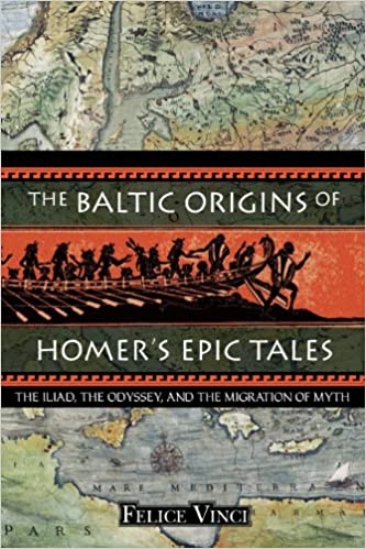 Ainsi, ce qui est étrange dans la longue bataille, dans la partie centrale de l'Iliade, avec deux midi (XI, 86 ; XVI, 777) et une "nuit terrible" (XVI, 567) mais sans aucune interruption des combats pendant la nuit - ce qui est impossible dans le bassin méditerranéen, où toutes les batailles sont interrompues par l'obscurité - est immédiatement expliqué : il s'agit d'une description de la nuit claire du solstice d'été dans les hautes latitudes qui permet aux troupes reposées de Patroclus, qui sont entrées dans le combat le soir, de combattre sans repos jusqu'au lendemain.
 D'autre part, les chercheurs ont trouvé des similitudes remarquables entre la représentation des figures de l'art minoen (mycénien et crétois) et certaines gravures uniques trouvées sur les dalles de sarcophage appartenant à un énorme monticule de l'âge du bronze (75 mètres de diamètre) à Kivik, dans le sud de la Suède. Et que dire de la présence d'un "graffiti" représentant une dague mycénienne sur un mégalithe à Stonehenge en Angleterre? En outre, on trouve dans cette région d'autres traces ("civilisation du Wessex") qui rappellent la civilisation mycénienne, mais qui semblent avoir précédé de quelques siècles ses débuts en Grèce. À cet égard, l'Odyssée mentionne un marché de bronze dans une localité étrangère, située outre-mer, appelée "Tamise", jamais identifiée en Méditerranée: en se rappelant que le bronze est un alliage de cuivre et d'étain et que, en Europe du Nord, ce dernier était produit presque exclusivement en Cornouailles, on pourrait en déduire que cette "Tamise" homérique correspondait à l'estuaire de la Tamise (appelé "Thamesis" ou "Tamensîm" dans l'Antiquité).
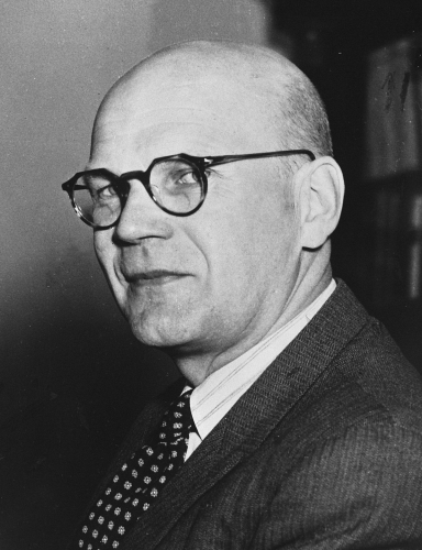
 Felice Vinci